The numbers,
with context.
The auditor record for 27460 Jackson Road, with the history and source alongside it.
County data last processed: 9/27/2026, 8:20:41 PM
Owner-supplied report added October 5, 2026.
This page transcribes the supplied report, not a live county balance. The report header shows $197,860.00; its valuation table separately lists the preliminary 2026 amount above.
Tax year 2025, payable 2026
Source PDF · page 4 ↗| Item | Delinquent | First half | Second half | Total |
|---|---|---|---|---|
| Gross tax | $0.00 | $2,276.28 | $2,276.28 | $4,552.56 |
| Reduction | Not shown | -$917.14 | -$917.14 | -$1,834.28 |
| Effective tax | $0.00 | $1,359.14 | $1,359.14 | $2,718.28 |
| Inflation cap credit | Not shown | $0.00 | -$252.68 | -$252.68 |
| Non-business credit | Not shown | -$111.56 | -$111.56 | -$223.12 |
| Owner occupancy credit | Not shown | -$26.64 | -$26.64 | -$53.28 |
| Homestead reduction | Not shown | $0.00 | $0.00 | $0.00 |
| Net general | $0.00 | $1,220.94 | $968.26 | $2,189.20 |
| Special assessments | Not shown | $0.00 | $0.00 | $0.00 |
| CAUV recoupment | Not shown | $0.00 | $0.00 | $0.00 |
| Penalty and adjustments | $0.00 | $0.00 | $0.00 | $0.00 |
| Billed | $0.00 | $1,220.94 | $968.26 | $2,189.20 |
| Payments made | $0.00 | -$1,220.94 | -$968.26 | -$2,189.20 |
| Due | $0.00 | $0.00 | $0.00 | $0.00 |
“Not shown” preserves a blank cell in the report; it does not mean zero. The auditor notes that payments after the second-half collection due date may appear against the relevant tax year and as a paid discrepancy in the following tax year.
Appraised & assessed values
Source PDF · page 1 ↗Appraised figures are labeled 100% in the report; assessed figures are labeled 35%. The 2026 row is explicitly preliminary.
| Year | Appraised land (100%) | Appraised improvements | Appraised total | Assessed land (35%) | Assessed improvements | Assessed total |
|---|---|---|---|---|---|---|
| 2026 · Preliminary | $45,410.00 | $186,380.00 | $231,790.00 | $15,890.00 | $65,230.00 | $81,120.00 |
| 2025 | $44,150.00 | $153,710.00 | $197,860.00 | $15,450.00 | $53,800.00 | $69,250.00 |
| 2024 | $44,150.00 | $153,710.00 | $197,860.00 | $15,450.00 | $53,800.00 | $69,250.00 |
| 2023 | $44,150.00 | $153,710.00 | $197,860.00 | $15,450.00 | $53,800.00 | $69,250.00 |
| 2022 | $30,620.00 | $111,730.00 | $142,350.00 | $10,720.00 | $39,110.00 | $49,830.00 |
| 2021 | $30,620.00 | $111,730.00 | $142,350.00 | $10,720.00 | $39,110.00 | $49,830.00 |
The historic chart appears on page 2 of the report. Values in the table above are transcribed from the numeric valuation table, rather than estimated from the chart.
The home in the auditor record
Source PDF · page 2 ↗The report lists 4 bedrooms, 2 full bathrooms, no half bathrooms, 1,808 square feet, a 1989 build year, and a 1995 remodel year. These are the county’s recorded entries. Current bathroom count, systems, and later renovations still need owner confirmation.
Dwelling 1 · layout & history
- Number of stories
- 1.0
- Style
- RANCH
- Year built
- 1989
- Year remodeled
- 1995
- Number of rooms
- 7
- Number of bedrooms
- 4
- Number of full baths
- 2
- Number of half baths
- 0
- Number of family rooms
- 1
- Number of basement garages
- 0
- Grade
- C0
Dwelling 1 · construction & systems
- Exterior wall
- ALUMINUM/VINYL
- Fuel type
- ELECTRIC
- Heat/cool type
- CENTRAL
- Attic
- NONE
- Basement
- CRAWL
- Total living area
- 1,808 sqft
- Main ground floor area
- 1,232 sqft
- Unfinished area
- 0 sqft
- Recreation room area
- 0 sqft
- Finished basement area
- 0 sqft
- Fireplace openings / stacks / prefab
- 0 / 0 / 0
Land, sketch & improvements
Source PDF · page 3 ↗| Land type | Land code | Frontage | Depth | Acres | Square feet | Value |
|---|---|---|---|---|---|---|
| ACREAGE | HOMESITE | 0 | 0 | 1.000 | 43,560.00 | $39,100.00 |
| ACREAGE | UNDEVELOPED/RESIDUAL | 0 | 0 | 0.549 | 23,914.00 | $5,050.00 |
| Totals | Not shown | Not shown | Not shown | 1.549 | 67,474 | $44,150.00 |
The land-detail total is $44,150.00, matching the 2025 valuation table. It is distinct from the preliminary 2026 land valuation of $45,410.00.
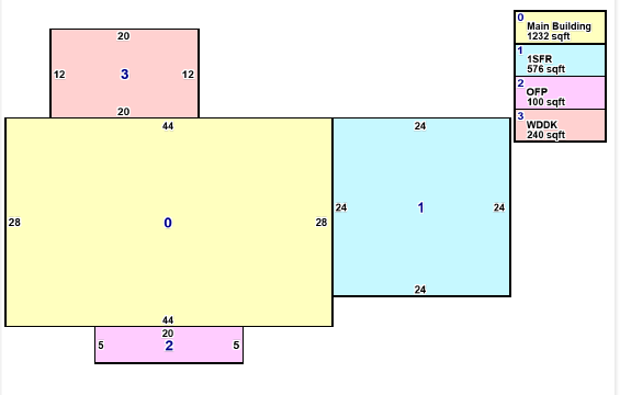
| Key | Report label | Dimensions | Area |
|---|---|---|---|
| 0 | Main Building | 44 × 28 | 1,232 sqft |
| 1 | 1SFR | 24 × 24 | 576 sqft |
| 2 | OFP | 20 × 5 | 100 sqft |
| 3 | WDDK | 20 × 12 | 240 sqft |
The source also contains a partial mini map and map-view links on page 1. No parcel boundary or geographic position is inferred from that thumbnail.
| Description | Card | Size (L × W) | Area | Grade | Year built | Appraised value | Assessed value |
|---|---|---|---|---|---|---|---|
| (AP1) - 4 SIDES CLOSED, METAL POLE BLDG | 1 | 24 × 24 | 576 | C | 1996 | $3,920.00 | $1,370.00 |
Improvement totals: $3,920.00 appraised; $1,370.00 assessed. Size, area, classification, and values are reproduced as shown by the auditor.
Ownership, location & legal record
Source PDF · page 1 ↗Parcel & location
- Parcel
- K2500020006800
- Situs address
- 27460 JACKSON RD OH
- City / township
- SALTCREEK TWP
- School district
- LOGAN ELM LSD
- Owner of record
- HARR JEFFREY D LINDSEY JO
- Ownership
- 100%
Mailing records
- Deeded owner mailing name
- HARR JEFFREY D LINDSEY JO
- Deeded owner address
- 27460 JACKSON RD, CIRCLEVILLE OH 43113
- Taxpayer mailing name
- HARR JEFFREY D
- Taxpayer mailing address
- 27420 JACKSON RD, CIRCLEVILLE OH 43113
The taxpayer mailing address differs from the property address in the report.
Legal description & classification
- Legal acres
- 1.549
- Legal description
- PART W1/2 (Not to be used on legal documents)
- Land use
- (511) R - SINGLE FAMILY, O-9.999 AC
- Section
- 16
- Township
- 11
- Range
- 20
Reductions & record identifiers
- Homestead reduction
- NO
- Owner occupied reduction
- YES
- Neighborhood
- 00220000
- Appraisal ID
- Not shown
- Card count
- 1
- Annual tax
- $2,189.20
Legal and ownership percentage entries appear on page 2. A blank appraisal ID is displayed as “Not shown.” The report’s legal description is expressly marked not for use on legal documents.
Recorded sales & transfers
Source PDF · page 3 ↗The summary lists 10/30/2018 at $130,000.00. The complete history below preserves the source’s validity codes, blank sellers, zero amounts, and duplicate-date entries.
The two October 30, 2018 rows have the same date, parties, conveyance number, and amount but different validity codes. They are not counted here as two independent comparable sales. “Parcel #” retains the auditor table’s column label.
Yearly tax value summary
Source PDF · page 4 ↗The source’s 2025 yearly summary shows net general of $2,441.88, while its detailed tax table shows $2,189.20. Both tables are preserved exactly; the $252.68 difference equals the inflation cap credit listed in the detailed table. Tax years are not interchangeable with payable years. Only the 2025 tax-detail tab is printed in this PDF.
Tax payment history
Source PDF · page 5 ↗Older payment dates and tax-year associations are retained as printed. No missing payments or years have been inferred.
Tax distribution · 2024
Source PDF · page 6 ↗| Tax unit name | Levy name | Amount | Percentage |
|---|---|---|---|
| Commission Of Aging | Commission Of Aging | $24.17 | 1.01% |
| Logan Elm Schl Dist | Logan Elm Schl Dist | $1,591.95 | 66.73% |
| Paint Valley Mental | Paint Valley Mental | $35.87 | 1.50% |
| Pcbdd | Pcbdd | $75.07 | 3.15% |
| Pickaway | Pickaway-Ross Jnt Voc | $121.58 | 5.10% |
| Pickaway County | Pickaway County | $182.34 | 7.64% |
| Pickaway County Park District | Pickaway County Park District | $22.06 | 0.92% |
| Salt Creek Township | Salt Creek Township | $332.74 | 13.95% |
| Totals | Not shown | $2,385.78 | 100% |
This distribution is for 2024, not the 2025 taxes payable in 2026. The original distribution chart is on page 5. Percentages are rounded as displayed in the report.
Other record sections
Permits
No Permit Records Found.
Source PDF · page 2 ↗Agricultural
No Agricultural Records Found.
Source PDF · page 2 ↗Commercial
No Commercial Records Found.
Source PDF · page 2 ↗Special assessments
No Special Assessment Records Found.
Source PDF · page 6 ↗“No records found” describes this report. It does not establish that no work took place or that a permit was not required.
Go back to the source
This independent property website is not the county auditor’s website. The supplied PDF is the source for the entries above, with data last processed 9/27/2026, 8:20:41 PM. A newer county record may differ.